Your asset. Your imagery. One connected workspace.
Turn 360° imagery, engineering drawings and inspection findings into a navigable visual record of your facility. Explore assets remotely, compare changes over time and manage dropped-object risks — all in one place.
One platform. Two solutions. Choose what you need.
RigScene brings visual asset information and inspection management into one platform. Start with 360° visual asset management, dedicated dropped-object management, or combine both to connect visual evidence directly to your inspection and risk records.
360°
RigScene 360
Build your own visual record of the asset. Capture and upload your own 360° imagery, navigate your facility remotely, link drawings and equipment information, and compare dated images to see how conditions change over time.
Manage dropped-object risks from identification to close-out. Record potential dropped objects on facility plans, assess severity, organise surveys by work area, track mitigation and removal, and maintain the evidence and audit history required to manage your PDO programme.
Turn site imagery into a working visual asset record
Capture your facility using cameras or drones you already operate. Upload your imagery, place capture locations on your plans, and build a navigable 360° record that your team can access remotely.
Plan360° viewFinding · inspection history · linked evidence
Capture on your termsControl your camera settings and image quality to suit your inspection requirements.
Process automaticallyUploaded panoramas are prepared for efficient viewing in the browser.
Navigate from the planMove directly from a deck plan or level drawing to the relevant location.
Connect engineering informationLink equipment tags, drawings, photographs and findings to the locations they relate to.
Compare over timeRevisit the same capture locations and compare dated imagery to review visible changes.
Optional module — RigScene PDO
Identify. Assess. Control. Verify removal.
Manage your dropped-object prevention programme through a structured, traceable workflow. Record potential dropped objects on facility plans, assess severity, assign mitigations, organise work by area, and track findings through to verified close-out.
IdentifyPin potential dropped objects on level plans or within 360° imagery where enabled.
AssessRecord condition, severity, supporting photographs and assessment details.
ControlDefine exclusion zones, document mitigations and organise surveys and repair work by area.
Verify removalRecord close-out evidence, maintain a timestamped audit history and generate reports for review.
Core capabilities
What you can do in RigScene
Each capability is covered in detail on the features page.
Tags & findings
Mark equipment and findings where they appear in the 360° view, then find them again on the plan or in the register.
Start with the capabilities you need today. Deploy RigScene 360 for visual asset management, RigScene PDO for dedicated dropped-object management, or combine both to connect visual inspections with risk management and reporting. Each module can operate independently, with the option to expand when your requirements change.
Shared platform capabilities
Multiple account types per company, with access and permissions suited to each role
Optional two-factor authentication (2FA) for an additional layer of account security
Custom-branded login page for your organisation
RigScene 360
Build and maintain your own visual asset record.
Capture your facility, create navigable 360° tours, link engineering information and compare imagery over time. Maintain your visual record using cameras and drones your team already operates. Image markup is not included in the 360-only package.
Plan-linked navigable tours and remote visual review
Tags, supporting photos, and drawings upload/linking
Dated capture and timeline comparison
Exposure and clarity tools in the 360° viewer
Advanced dashboards for metrics and KPI tracking where enabled
Custom jump points from the plan into specific views
Local point-cloud captures linked to equipment tags
Maintain your PDO register, assess severity, organise work areas, track mitigation and removal, and generate reports with supporting evidence and audit history. No 360° imagery is required.
PDO register and location on level plans with severity assessment
Mitigation and status tracking, exclusion zones, and work areas
Drawings upload/linking and timestamped audit history
Monitoring for long-term PDOs that are difficult to remove
PDF report generation, CSV exports, and programme dashboards
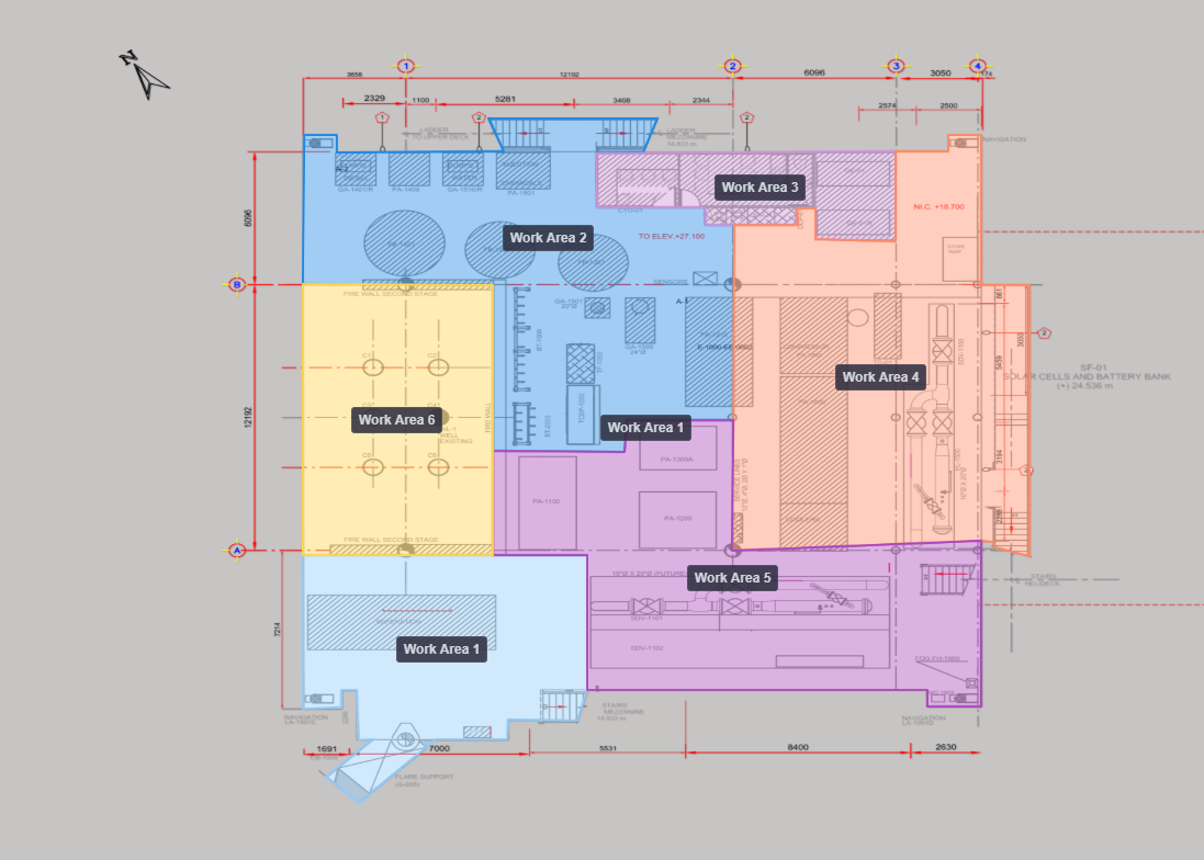
Subdivide level plans into defined Work Areas
Advanced search to locate PDOs or equipment tags by Work Area
Connect visual context with dropped-object management.
Combine navigable imagery, inspection findings, engineering drawings and PDO records within the same asset structure. Give teams the visual context and traceability needed to manage findings and document close-out.
Everything in RigScene 360 and RigScene PDO
Link 360° views to PDO findings on the plan
Image markup on PDO and supporting imagery
Search PDOs and equipment tags together by work area
Tell us about your facility, inspection requirements or dropped-object programme. We can walk you through the relevant capabilities and discuss a demonstration or pilot using your operational requirements.
See how RigScene could work for your asset
Tell us about your facility, inspection requirements or dropped-object programme. We can walk you through the relevant capabilities and discuss a demonstration or pilot using your operational requirements.
Get in touch
Have a question about RigScene, deployment options or a specific use case? Send us a message and we’ll get back to you.
Thanks for your message. We'll get back to you soon.
Something went wrong. Please try again or email info@rigscene.com.
Frequently asked questions
Modules, demos, and how PDO management works with or without 360°.
What is PDO management?
PDO management is the dropped-object programme: identify potential dropped objects, assess severity, control them, and verify removal. RigScene PDO is the software that runs that programme on the deck plan.
Can I use RigScene 360 and RigScene PDO separately?
Yes. They are independent modules. Run RigScene 360 alone, RigScene PDO alone, or both together. RigScene PDO runs on maps, the register, evidence and reports without any 360° capture.
How can RigScene reduce unnecessary site visits?
Teams can use remote visual review and in-house 360 capture where it is suitable, and keep PDO registers and audit evidence connected on the plan — which can reduce repeat mobilisation for visual checks and time spent rebuilding packs. Outcomes depend on your programme and how you use the platform.
Can I capture my own 360° imagery?
Yes. Capture with 360 cameras or drones you operate, then upload into RigScene 360. You are not locked into a vendor crew for every refresh.
How are 360° images processed after upload?
RigScene 360 processes each upload automatically in the app, generating preview and tiled resolutions for fast navigation across the tour. You can also adjust exposure and clarity in the viewer when you need a clearer look at detail.
What is a dropped object survey?
A dropped object survey is an inspection against the industry Dropped Objects Prevention Scheme. In RigScene PDO you pin findings on the deck plan, attach evidence, and close with verified removal. See Dropped object surveys.
Do you offer 360 virtual tours for oil and gas?
Yes. RigScene 360 is built for oil and gas and offshore assets: your team captures the imagery and the tours sit on your deck plans and level drawings.
How is this different from a 3D twin or a BIM field tool?
RigScene is a visual asset management workspace — RigScene 360 for capture and exploration, RigScene PDO for dropped-object programmes. You do not need a specialist visual twin or construction BIM to run either module.
Can RigScene show a local point-cloud capture?
Yes. Upload a local point-cloud capture for a modification or a smaller area and measure it in the browser, alongside the 360° record. See point-cloud visualisation. RigScene is not a whole-asset point-cloud platform.
How can I arrange a demo?
Contact us for an overview and demo access on your asset.